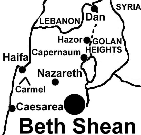
| Beth Shean from the Old Testament city to the lower Roman City with a theater and a public latrine (Restroom) |
|
| |
 |
Civilization first settled at Beth Shean 4000 BC south of the Harod River in the fertile soil, with springs of water on the cross roads of trade where the Jezreel/Jordan Valleys meet..
Egypt ruled in Beth Shean when it was a Canaanite city 1500-1100 BC. Joshua did not take Beth Shean (Judges 1:27) and the Philistines displayed the bodies of Saul and his sons on their city walls (1 Sam.31:10).
Not until David took Beth Shean (along with Megiddo and Ta’anach) did Israel occupy the city. Solomon made it an administrative center (1 Kg.4:7). Tiglath-Pilesser destroyed the city in 732 BC. The remains of this OT city can be seen in the tel setting next to the Greek/Roman city called Scythopolis that was built in its place during the Hellenistic period. The Hasmoneans took the city in 107 BC. The Gentiles were exiled and it became a Jewish community. Rome took the city in 63 BC and Beth Shean (Scythopolis) became one of the ten citeis of the Decapolis and the predominant city in northern Israel. Rome executed the Jewish residents in 66 AD at the beginning of the Jewish revolt. From that time on into the Byzantine period Beth Shean was a mixed culture of Greeks, Jews and Christians growing to a population of 30,000-40,000. The city was Christianized but the Arab conquest slowed its growth. An earthquake in 749 AD leveled the city. The devastation of this earthquake can still be seen today. Some of the sites visible today are: 1) Theater, 2) Bathhouse, 3) “Palladius Street”, a colonnaded street, 4) Sigma, a semicircular concourse surrounded by rooms, 5) Agora, 6) Roman Temple, 7) Northern Street, a colonnaded street leading to the NW city gate, 8) Nymphaeum, 9) Public lavatories (bathrooms), 10) Valley Street and the Truncated Bridge, 11) Amphitheater, 12) Tel Beth Shean from the OT |
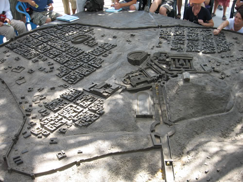
The model of the city of Beth Shean.
Notice the street or colonade running from the theatre (half round building) to the hill with the building on it. The hill is the Old Testament city of Beth Shean where Saul's body was hung on the wall. |

The colonade street that runs between the theatre and the base of the tel or hill of the old city is in the picture below. |
This is a view looking down the colonaded street to the tel or hill of the old city. The theatre is to the right of the picture.
This lower city was a Roman city built after the Old Testament.
The O.T. city is the tel in the back ground. |
|
| Here is a close up of the theatre model and the colonaded street. |
|
| The theatre. |
|
The stage with the colonded street of the New Testament Gentile city.
In the background is the Tel of OT Beth Shean. In front are the theater and the colonnaded streets of Scythopolis
|
|
| A nice view of the standing columns of the colonaded street in the background of the theatre stage. |
|
| Pillars in the corner of the front of the theatre. |
|
| Close up of the tops of the pillars in the corner of the stage. |
|
Straight up the colonaded street to the tel.
Notice the middle stones on the pavement. Under them is a channel for the gutters to run the rain water. |
|
| The columns |
|
| At the end of the street and at the base of the tel we turn to the right to see some serious destruction caused by an earthquake in 749 AD. |
|
| The collapsed columns of 749 AD |
|
| Notice the pillar penetrated the road stones and popped them up out of the road. |
|
A model of the building that the fallen pillars were from.
This building is called Nymphaeon.
The actual building is in the background of the model. |
|
| Continuing to the right we see more remains of the building in the mode. |
|
This is the front of the building in the model.
In the background you can see the colonaded street running back towards the theater.
The tel (hill) of the Old Testament city is to our backs in this photo. |
|
| This is further down the street after we turn right off of the colonaded street. |
|
Up on the tel of the Old Testament city of Beth Shean.
Here the view is to the east. In the distance you can see the Jordan River and the other side of the river into the modern country of Jordan.
|

The walls of this city right here may have been the place Saul's body was hung by the Philistines. |
| The ruins of the old city on the top of the tel. |
|
This is the view of the colonaded street from the tel of the old city.
Notice the theatre at the end of the colonaded street just to the left of the end of the pillars. |
|
This is a view of the Roman city from the tel of the Old Testament city.
The building in front matches the model above.
Notice again the colonaded street and the theatre. |
|
| A Greek inscription |
|
| Model of the large arena or hippodrome in the city |
|
| A piece of pottery found by Galyn in the remains of the Portico in front of the theatre. |
|
Handles found in Beth Shean by Galyn.
The dark handle is of basalt stone and would have been a Jewish vessel able to be washed and reused if it ever became unclean.
The clay handle is from a vace that would have to be thrown away by a Jew if it ever became unclean. |
|
| Galyn holds the base of a jar found in Beth Shean along the colonaded street. The street was called Palladius Street. |
|


